Colonial period building on the lower Juba
 Photo taken in 1988, at the mouth of the Juba, on the north side of the river.
It could be Italian or English. This area, known as Jubaland, was once under British colonial control
Possible location: Lat and Long 0°14’55.8″S 42°37’04.0″E
-0.248845, 42.617769
Jama mosque, circa 1880
 From “Voyage Chez Les Benadirs, Les Comalis et les Bayouns, par M.G. Revoil en 1882 et 1883″
Published in Le Tour du Monde. Noveau Journal des Voyages. XLIX, 1255 Liv, page 61
Location in Xamar Weyne, courtesy of Google Maps. Minara is visible within the red circle
 Lat and Long: 2°01’56.8″N 45°20’31.6″E
2.032442, 45.342114
Cabdul Aziz mosque, circa 1880
 From “Voyage Chez Les Benadirs, Les Comalis et les Bayouns, par M.G. Revoil en 1882 et 1883″
Published in Le Tour du Monde. Noveau Journal des Voyages. XLIX, 1254 Liv, page 46
Revoil and his colleague are in this scene, wearing turbans, located to the left of the camera on the tripod
Location as shown by Google Maps. Given the location of mosque relative to minara, it seems that the above drawing was based on a location to the south east of the minara

Lat and Long: 2°02’13.3″N 45°21’12.3″E
2.037035, 45.353426
Alas, it is no more, after being damaged by fighting between Al Shabab and OAU forces a few years ago, and then in 2013 demolished by order of the current government, with a promise of being “rebuilt” by Turkey
Here are some photos of inscriptions inside of the adjacent mosque (also damaged during the fighting), taken by Mary Harper before its demolition
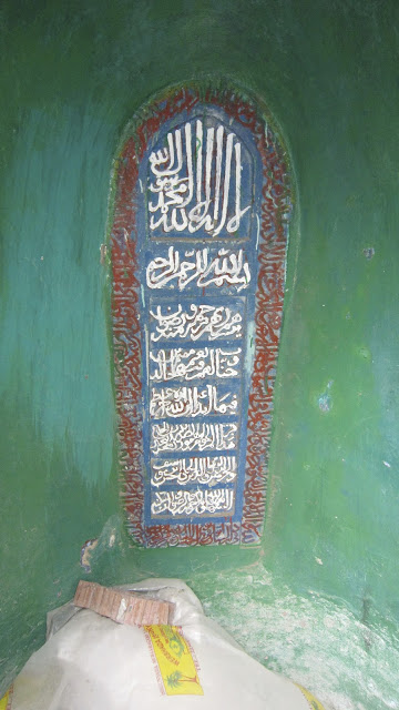
Located at the back of the mihrab?
 Old inscription or simply recent text written in chalk?
Location unknown…any ideas?
Fakhr al-Din mosque, circa 1882
 From “Voyage Chez Les Benadirs, Les Comalis et les Bayouns, par M.G. Revoil en 1882 et 1883”
Published in Le Tour du Monde. Noveau Journal des Voyages. XLIX, 1255 Liv, page 51
More engravings from the same source:


For more information about the marbles, see
Lambourn, E.(1999) ‘The decoration of the Fakhr al-Dīn mosque in Mogadishu and other pieces of Gujarati marble carving on the East African coast‘, Azania: Archaeological Research in Africa, 34: 1, 61 — 86 To link to this Article: DOI: 10.1080/00672709909511472 URL: http://dx.doi.org/10.1080/00672709909511472. The first paragraph, showb below, suggests that the marbles shown above may not longer be in place:
 The following photos are included in the above paper


 Is this four layered inscription above the arch the same as marble incriptions photographed by Revoil and shown above (but in the proper vertical order)?
Pre-colonial port, remains circa1882
 From “Voyage Chez Les Benadirs, Les Comalis et les Bayouns, par M.G. Revoil en 1882 et 1883”
Published in Le Tour du Monde. Noveau Journal des Voyages. XLIX, 1255 Liv, page 49
Text on page 50 refers to this view [courtesy Google Translate):
Along the narrow streets of Harmarhouine amid the huts and miserable huts along them, we arrive at the mosque of Hussein Arbou . This edifice , without much importance , dominates a small cove almost square, closed by the nature in which the sea, which breaks with fury on the rocks, pours a veritable cataract of foaming waves , while iridescent by the rays of the sun . Some sections of blackened walls surrounding the mosque, based as it on an entablature of the cliff and peak ground in many places by the hand of man . A little further , the old men say , was a tower of similar construction to the Abdul Aziz tower , and high enough so that we could see it from Meurka . This tower , no marks on the rock, however, it differs in the reef a sharpened screw which, through arched doorway , built strong regularly and a Moorish character quite remarkable staircase gives access to a cave formed by the upper entablature . No clue, no registration revealed the date of the ruins. The other side of the creek, a cut in the rock street is facing the door , and can still be seen , right and left , a few walls identical to those adjoining the mosque. This cove she was a small port of refuge intended to park the boat against the violence of the monsoon ? or was it used basin repair a flotilla of Moguedouchou ? It is difficult to say today , but there has certain is that the cave and its surroundings bear traces of human labor . I have natural claims to have found several times small pieces of gold , as for me, I have hardly discovered around these lands broken fragments of pottery and glass beads without much interest. South of the basin , which extends the space between the mosque of Hussein Arbou and that of Aoues al- Garni forms a small cove covered at high tide. The low tide leaves has discovered a kind of platform rocks mishap by algae , and there is generally less research by women for bathing or laundry. Holes that serve tubs or swimming pools seem to have been in all probability foundations of a dead city , once sitting on rocks. But since water and sand walks slowly to the conquest of the rocks, and it was difficult for me to really reconaitre if these ruins were the same age as the Arbor -Hussein stairs. Who can say how many thousands of years have passed since the first inhabitants of these beaches?
If you think you can improve this admittedly rough translation contact me and I will send the original French text
Here below is a later view of the area, shown in a map titled “Oceano Indiano – Somalia Italiana Ancoraggio di Mogadiscio. Dai rilievi Originali della Regia Nave – Staffetta,, 1911 e da Quelli Successivi Fino al 1934” [Indian Ocean – Italian Somalia Anchorage of Mogadishu. Original Surveys by the Royal Ship “Relay” 1911 Subsequent to Those Until 1934 “] The “small cove almost square” can be seen in the red circle. Around 1985 I remember seeing the eroded remains of a spiral staircase that had been cut down into the rock, giving access to the water line within the cove

And here is a Google Earth view of the same location, showing the mosque on the top right of the cove
 Lat and Long: 2°01’52.0″N 45°20’34.5″E
2.031104, 45.342908

North coast of Somalia, circa 1857
 Click on image to enlarge
“Karte der Somali – Kuste und des Golf’s von Aden. Th. von Heuglin’s Reise, September bis December 1857”
Kismayu, circa 1889
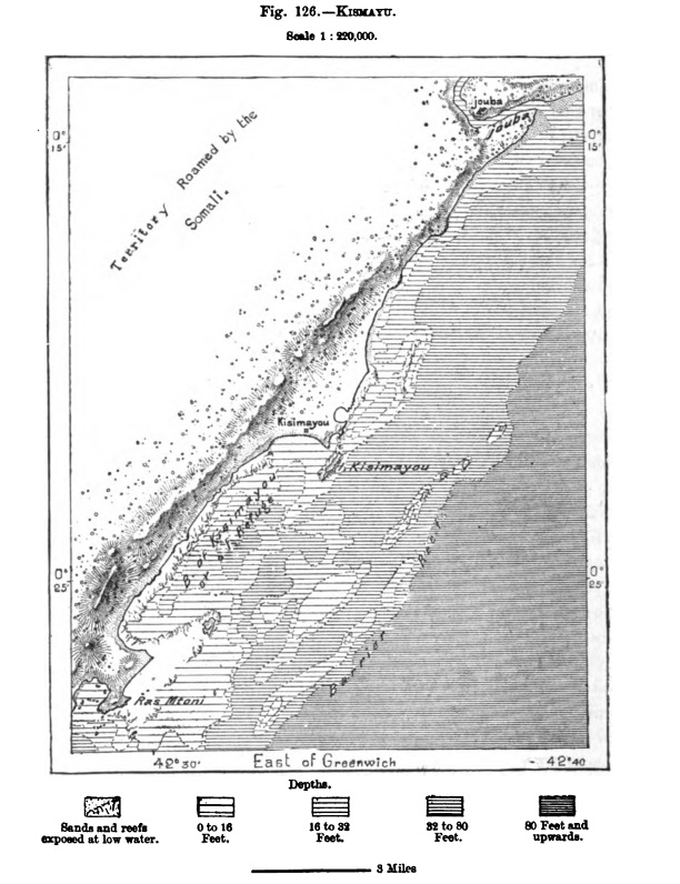 The map comes from ” The Earth and its Inhabitants: Africa (South and East Africa)”, authored by Elisee Reclus and published by the D. Appleton and Company. 1889. Pages 407-409
KISMAYU-BRAVA.-MERKA.
“Kismayu, or Kisimayau is the last anchorage on the Somali coast, going north eastwards in the direction of Cape Guardafui, to which the term port can be applied. But even this place is little used except as a harbour of refuge, so little developed is the movement of exchanges along this inhospitable seaboard. Nevertheless, Kismayu is the natural outlet of the vast basin of the Juba, which reaches the sea about 12 miles to the north-east. In 1869 this town did not yet exist, but in that year some Somali emigrants from the Upper Juba Valley, and especially from the neighbourhood of Bardera, or Bat Tir, the chief market of the interior, established themselves at this favourable point of the coast, and opened direct commercial relations with Zanzibar. Later some members of the Mijurtin tribe, the most energetic traders on the whole seaboard, also settled in the same place, the population of which had already risen to eight thousand six hundred in the year 1873. At that time the suzerainty of the Sultan of Zanzibar was represented in Kismayu by some Arab traders and a small Baluchi garrison. In 1870 a Marseilles commercial house had hoisted the French flag in this port, but after the battle of Sedan the Sultan of Zanzibar hastened to reassert his authority over the place.
Bardera is inhabited by Mohammedans, who if not actually Wahabites, are fully as fanatical as those troublesome sectaries. They neither smoke nor take snuff, and display an almost rabid zeal in their efforts to enforce their peculiar views on the surrounding Somali populations. Hence insurrections, massacres, migrations. of tribes, and disorders of all sorts. In the year 1845, the town of Bardera was utterly destroyed by the enraged inhabitants of the district, who slew all the men and sold the women and children into bondage. A few fugitives, however, contrived to break through the fiery circle closing round the doomed city, and going northwards to the Ganane country, founded a town on the left bank of the Webi, which has flourished, and is now a great centre of trade. Bardera also again rose from its ashes, and with it was revived the old spirit of religious intolerance. Here were massacred in 1865 the two travellers Link and Von der Decken The vessel with which the unfortunate explorers had navigated the river, and which the natives had succeeded in recovering from the rapids, was till recently used by them as a ferry-boat between the two banks of the Juba”
The full text of the book is available online here (in a big .pdf file)
Berbera, circa 1889
 The map comes from page 413-414 of ” The Earth and its Inhabitants: Africa (South and East Africa)”, authored by Elisee Reclus and published by the D. Appleton and Company. 1889.
Text above and below the map, and on the back side of the map, reads as follows:
MAYET – BERBERA – BULHAR 412
Other havens or roadsteads follow in the direction of the west, where Mayet (Mehet) is the seaport of the Habr Ghar-Haji people. According to the local
MAYET – BERBERA 413
tradition, here died the great Sheikh Ishak) ancestor of all the Habr or ” Grandmother” tribes, which belong to the widespread Hashiya division of the Somali race. Formerly the Somali advanced in years came from all the surrounding regions and settled near the venerated shrine, in order after death to secure a last resting-place near the remains of the founder of their nation. All the houses and cabins of Mayet were at one time grouped round about the tomb of the saint; but they have since been displaced in the direction of the west, near the mouth of a little coast-stream. Towards the north-east is visible the volcanic islet of Jebel- Tiur, or ‘Bird Mountain,” which contains a deposit of guano, and to which the English have given the name of Burnt. Island, from the colour of its lavas. The island is annually visited by about forty Arab dhows, from the port of Makalla in Hadramaut, returning laden with cargoes of this manure for their tobacco plantations.
West of Mayet follow the seaports of Heis, Ankor’, Kerem, all of which belong to the Habr Tol nation. Then, after rounding a headland, the seafarer comes in fuIl view of a deep inlet in the coast forming the important harbour of Berbera. This 3 the only thoroughly sheltered haven on the whole seaboard, and has consequently been a busy seaport from the remotest antiquity. The town still keeps the old lame of Barbaria formerly applied by the Greeks, not to any particular point, but
SOUTH AND EAST AFRICA 414
to all the coastlands skirting the south side of the Gulf of Aden. Yet notwith¬standing its obvious maritime advantages, this privileged seaport has at times been completely abandoned. Thus a war which broke out in the year 1870 between the surrounding Gadibursi and Dolbobant nations compelled all the inhabitants of Berbera temporarily to quit their homes. But under the protection of Great Britain, which has inherited all the rights of Egypt as the ruling power on this seaboard, Berbera has again become the centre of considerable commercial activity. It has now a lighthouse, piers, warehouses, and even an aqueduct, whose copious water, thermal at the fountain-head, is brought from a distance of about seven miles. Berbera is the successor of Bender Abbas, another town some ruins of which are still visible on the low-lying shores of the Tamar peninsula enclosing the road¬stead on the north and north-west. Lying 160 miles to the south of Aden, and nearly under the same meridian, Berbera shares with that town and with Zaila, another port belonging to England, the whole of the commercial movement in the western parts of the Gulf of Aden.
On the beach at Bullhar, about 45 miles farther west, lies the market-place where the Berbera traders meet the caravans coming from Harrar and from all the Somali and Galla Lands to ,the south and west of that place. During the busy season, from October to January, as many as 15,000 persons are attracted to this place. Then, after all the commodities have changed hands, the tents are struck, the long strings of camels laden with their purchases move off in all directions towards the interior, the Arab dhows set sail, and solitude once more prevails along the seaboard. The Somali prefer the Bulhar market to that of Berbera itself, because they find in the, neighborhood convenient pasturages for their numerous herds and Hocks, whereas round about Berbera nothing is offered except here and there a few trailing plants and shrubs. Bulhar has unfortunately no harbour, and its surf-beaten shores are too often strewn with wreckage. The explorers who have ventured to penetrate from this point into the inland plateaux report the existence of numerous burial-places.
The most frequented trade route running south• westwards in the direction of the city of Harrar has its seaward terminus at Bulhar. But Samawanak and Dungareta have been spoken or as more convenient starting-points for the future railway, which has already ‘been projected, and which must sooner or later run through the Gadibursi territory towards the great city of the Upper Webi basin, easternmost station and bulwark of the kingdom of Shoa. Accordingly England and France have recently put forward rival claims for the possession of this future gateway to the interior of the continent from this direction. The English mean¬time retain in their hands the disputed station, recognising in return the absolute sovereignty of France over the Gulf of Tajurah, which also gives access to the inland regions from the head of the Gulf of Aden.
The full text of the book is available online here (in a big .pdf file)

“Map of the Somauli Coast Showing the Position of the Tribes…”
“….by Lieutenant C.J. Cruttenden. I.N., with additions from the Surveys of Capt. Owen, R.N. Liets, Barker, Christopher & Carless, I.N”
Published in the Journal of the Royal Geographical Society, London 1849

The generous description of the Nugal valley on this map reminds me another place described by a friend Axmed I J…many years ago, a place where there were “valleys of milk, valleys of honey and valleys of good pasta” 🙂
Le filage, l’encollage et le devidage du coton a Moguedouchou – Dessin de Riou, d’apres une photographie de auterur
 Click on photo to enlargen
Published in 1885, in Le Tour du Monde: Nouveau Journal Des Voyages, by Charton, Edouard, 1807-1890
Volume XLIX> Voyages chez les Benadirs, Les Comalis et les Bayouns, par M..G. Revoil en 1882 et 1883 . Texte et Dessins inedits
Magadishu vista da ovest & Magadishu dal mare
 Click on photo to enlargen
Appears to be looking towards Shangani…

Click on photo to enlargen
Looking towards to the Garessa (possibly) in the centre, with Fakr ad-Din Mosque and Xamar Weyne on the left and Shangani on the right. Taken from near the beach
Associated text: “Porto di Mogadiscio Sud Protettorato Italiano Somalia”
Add your comments
A Somali village

Page 80, The Graphic, July 26, 1884
One of three engravings collectively titled “Territory Recently Occupied by Our Troops in East Africa”
Click twice on the image to get a very detailed view
The location as shown by Google Maps
A street in Berbera

Page 80, The Graphic, July 26, 1884
One of three engravings colelctively titled “Territory Recently Occupied by Our Troops in East Africa”
Click twice on the image to get a very detailed view
The location as shown by Google Maps
Berbera, on the Gulf of Aden

Page 80, The Graphic, July 26, 1884
One of three engravings collectively titled “Territory Recently Occupied by Our Troops in East Africa”
Click twice on the image to get a very detailed view
The location as shown by Google Maps
Zaila / Zelya / Zeila / Seylac
“The Town and People of Zaila, Somali Coast, Africa”
Photos and text from The Graphic, May 7, 1887, page 473
 The game referred to in the text above may be one called “shax”. Here is a guide to the game, which I wrote in the 1980s


Photos of Zeyla on the internet
- Ottoman built Saylac (Zeila) governor house, 1850s. (Probably more likely to be British-era building)
Google Maps view of Zeyla
La grand Lab de Moguedouchou – Dessin de Y. Pranishnikoff, d’apres une photographie de l’auteur
 From page 59, “Le Tour du Monde”, 1885
Possibly in the location shown below, which has Xamar Weyne to the left and Shangani to the top.
In the 1885 print above the tower in the right distance may be the old minaret in Cabdul Aziz district, seen on this 1889 map, marked “tour“
Notre boutre dans la rade de Moguedouchou (voy. p.28) – Dessin de Rio, d’apres des photographies et des documents fournais par l’auteur
 From page 25, “Le Tour de Monde” magazine, 1885
Mogadishu, 1882
The Market Place in Mogadishu in 1882 From E. Cerulli, Somalia, Scritti Vari Editi ed Inediti, Vol. 1., Fig. XIV. Istituto Poligrafico dello Stato, P.V., Rome, 1957 (5)
This print shows the upper of the two beaches on the 1934 map shown below. The mosque to the far left (two cones on roof) was still in existence in the1980s, and can be seen in the photos below.

1 comment