Mogadishu: Images from the Past

“La via principale di Mogadiscio”

Posted in 1900 - 1918, Street scenes by rickjdavies on 26 April, 2013

The main streetClick on photo to enlarge

“The main street of Mogadishu”, circa 190 (from an Italian magazine). Where is this scene? Leave your comment below

“Mogadiscio – interno della moschea Giama”

Posted in 1900 - 1918, Religion by rickjdavies on 26 April, 2013

Inside Giama MosqueClick on photo to enlarge

“Mogadishu – Interior of the Giama mosque”, circa 1901 (from an Italian magazine). Any comments?

Giama mosque textFrom page 15 of “Mogadishu: Pearl of the Indian Ocean” (pdf copy here)

“Autorita indigene di Mogadiscio”

Posted in 1900 - 1918, People by rickjdavies on 26 April, 2013

Indigenous authorities 1901Click on photo to enlarge

Indigenous authorities of Mogadishu”, circa 1901 (from an Italian magazine). Who are the people shown here and where was the photo taken? Leave your comment below.

“Mercato di Mogadiscio”

Posted in 1900 - 1918, Markets by rickjdavies on 26 April, 2013

Mercato di Mogadiscio 1901Click on photo to enlarge

“Market of Mogadishu” circa 1901 (from an Italian magazine) Possibly the Garessa on the left and Shangani in the middle distance. What do you think? Leave your comment.

“Mogadiscio”

Posted in 1900 - 1960 Italian Period, Aerial photographs by rickjdavies on 23 April, 2013

Mogaerial photo from vintrage somaliaClick on photo to enlarge

Photo copied from Vintage Somalia – a website worth visiting, with a large and eclectic collection of photos

When was this photo taken? Leave your comment below

Boondhere district is visible as a new settlement in the distant centre and right

“Mogadiscio – Viale Cerrina”

Posted in 1900 - 1918, Govt buildings, Street scenes by rickjdavies on 20 April, 2013

Viuale CerrinaClick on photo to enlarge

Viale Cerrina, later named Via Vittorio Emmanuel, then Via Somalia (I think). Leave your comment below

Fakhr al-Din mosque visible in the centre

FaD mosque textFrom page 15 of “Mogadishu: Pearl of the Indian Ocean” (pdf copy here)

“Mogadishu – Panorama”

Posted in 1900 - 1918, Street scenes by rickjdavies on 20 April, 2013

PanoramaClick on photo to enlarge

Location unknown, but appears to be looking inland

Leave your comment

“Mogadiscio – Campo Amnara”

Posted in 1900 - 1918, Govt buildings by rickjdavies on 20 April, 2013

Campo AmnaraClick on photo to enlarge

Campo Amhara, in what was latter called Abdul Caziz District (I think). Centre of town to the right.

Leave your comment on where this is

Mosque Sheikh Sufi

Posted in 1900 - 1918, Mosques, Religion by rickjdavies on 20 April, 2013

Mosque Sheikh Sufi

Somalia - Mogadiscio- La Tomba di Scek SuffiMoschea Scek-SufiSheik Sufi mosque

Where is this? Leave your comment

Thanks for the comments below, based on those comments this seems to be the location…(Correct me if I am wrong)

Lat and Long: 2°02’17.7″N 45°20’11.3″E
2.038251, 45.336476

“Mogadiscio – Mercato indigeno”

Posted in 1918 - 1940, Markets, Mosques by rickjdavies on 20 April, 2013

Mercato indigeno_001Mogadishu – indigenous market. Post card poisted 20/11/1924

Possibly with Sheik Sufi mosque in the far left

Where do you think this is? Leave your comment below

“Mogadiscio – Villagio indigeno fuori << Porta Mercato"

Posted in 1900 - 1918, Markets, Street scenes by rickjdavies on 20 April, 2013

Villagio IndigenoRough translation: “Indigenous village outside Port Market”

Where is this location? Leave your comments below

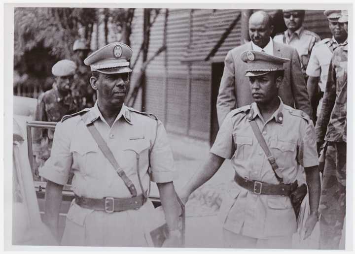
“General Mohamed Siyad”

Posted in 1969-1991 Barre period, People by rickjdavies on 15 April, 2013

Barre“Leader of the military coup ousting Premier Egal, Commander of the Somalia Armed Forces shown here with his adjuntary (a major) outside the military headquarters in Mogadiscio” In 1969

“R.C.M Somali – Hutte Somali en construction. Building Somali hut”

Posted in Y: Unknown locations by rickjdavies on 13 April, 2013

aqalClick on photo to enlarge
Location unknown. Leave comments if they will help

R.C.M may stand for Roman Catholic Mission

“Somalia – Mogadiscio – La Fontana della Garesa”

Posted in 1930s, Govt buildings by rickjdavies on 13 April, 2013

2013 04 13 DClick on photo to enlarge

Postcard posted 2/3/1937

“Somalia Italiana – Il te (ciai) della cinque”

Posted in 1950s, People, Y: Unknown locations by rickjdavies on 13 April, 2013

2013 04 13 BClick on photo to enlarge

Where is this location? In the background are what look like three or four sandy roads heading uphill and away from the photographer. These may be the outskirts of Mogadishu at the time.

Note the silver jewelery worn by the women. Similar if not the same as the item below, in the case of the women on the left (click to enlarge, twice)

2013 04 13 C

“Ost-Africa und Madagascar. 1857”

Posted in 1800 - 1900, Maps by rickjdavies on 13 April, 2013

1857Mapb

Click on photo to enlarge

Somali music from the 1980s

Posted in 1980s, Audio, Media by rickjdavies on 12 April, 2013

I hope to create a list here, including audio files and links to other websites with audio files. Here is one

Mogadiscio – Via Piemonte

Posted in 1918 - 1940, Street scenes by rickjdavies on 11 April, 2013

TowerIn Xamar Weyne. Tower in central distance is part of Giama Mosque. It is visible in 19th century maps of Mogadishu.

“Mogadiscio – Ginnasio Emilio De Bono”

Posted in 1930s, Govt buildings by rickjdavies on 11 April, 2013

SchoolPostcard posted 26/6/1935

Where is this building?

“Map of the Somauli Coast Showing the Position of the Tribes…”

Posted in 1800 - 1900, Maps, Wells by rickjdavies on 10 April, 2013

“….by Lieutenant C.J. Cruttenden. I.N., with additions from the Surveys of Capt. Owen, R.N. Liets, Barker, Christopher & Carless, I.N”

Published in the Journal of the Royal Geographical Society, London 1849

1848ac

The generous description of the Nugal valley on this map reminds me another place described by a friend Axmed I J…many years ago, a place where there were “valleys of milk, valleys of honey and valleys of good pasta” 🙂